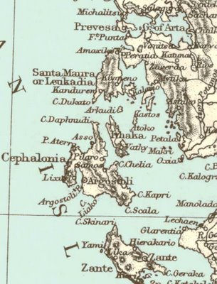
Detailed map of Petri's home. Island of Ayamavri and Lefteri Kaptan's Kefalonya
Santa Maura/Leukadia and Cephalonia(Detail from Map)The Balkans. Entitled Turkey and Greece, includes the provinces of Roumania, Servia, Bulgaria, Bosnia and Montenegro, as well as Moldavia, Roumelia and Greece. Map by Edward Weller. Issued by Blackie & Son about 1875.
formerly Levkás (both: lfkäs´)or Leucas (l´ks), mountainous island (1991 pop. 19,350), c.115 sq mi (300 sq km), W Greece, in the Ionian Sea; one of the Ionian Islands. Lefkás (1991 pop. 6,344), the chief town and the capital of Lefkás prefecture, is at the northern end of the island. Olive oil, currants, wine, and tobacco are produced. The island was colonized (7th cent. B.C.) by Corinthians, and Corinth and Lefkás were allies in the Peloponnesian War. Lefkás later was the capital of the Acarnanian League (3d cent. B.C.). The island was captured (1697) from the Ottoman Turks by Venice, which held it until 1797. There are ruins of Cyclopean walls and a temple to Apollo Leukates. Sappho is said, probably falsely, to have committed suicide by plunging into the sea from a cliff of the island. Lefkás is also known as Santa Maura.

No comments:
Post a Comment